- WG2. Applied Geophysics
Coordination: João Carvalho, LNEG
Co-coordination: Bento Caldeira, UÉ
Institutions: FCUL, FEUP, ISEL, IST, LNEG, UÉ
Working group presenting sets of data, services and products in exploration geophysics, in particular seismic, potential, electrical and electromagnetic methods.
Aims to address new targets through integrated and innovative methodologies, to participate in joint applications for research projects and to provide multidisciplinary geophysical services.
Our resources on applied geophysics cover the following methods:
Our resources on applied geophysics are of various types:
+ DATA & PRODUCTS
| + SEISMIC |
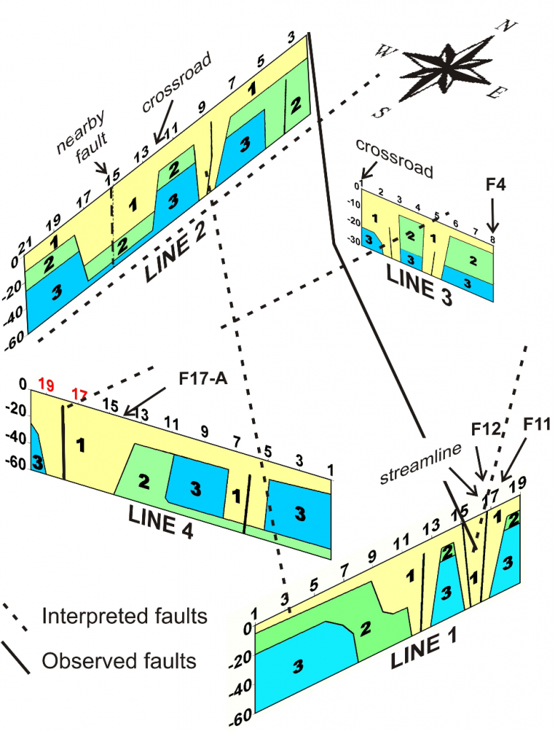
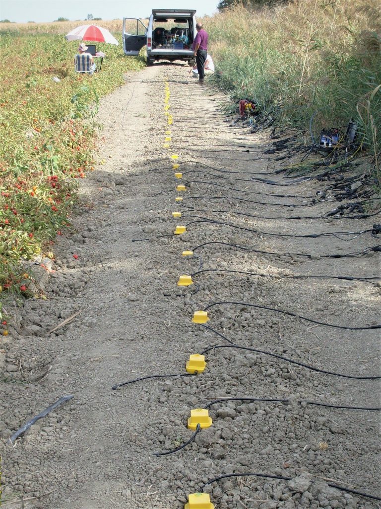
| . Shallow seismic reflection and refraction profiles raw data and derived products (SEG-2/SEG-Y) Includes Faial island, Azores. . Seismic tomography data and derived products . Seismic noise (SAC) Continental Portugal – Tagus valley; Azores – islands of Faial, Pico and S. Jorge; Argelia – Mitidja Basin. |
| + GEOELECTRIC |
| . Electric resistivity tomography profiles (PASI) Tagus valley, Portugal. . Resistivity and Induced Polarization profiles Various areas of Portugal. |
| + ELECTROMAGNETIC |
| . Electromagnetic profiles (EM38) Various areas of Portugal. . Georadar profiles (DZT) Tagus valley, Portugal. |
| + MAGNETIC |
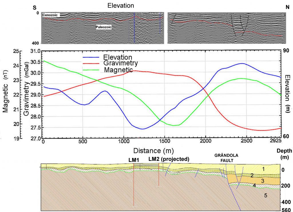
| . Magnetic profile data (ASCII, GSM 19) Portugal, Spain and Marocco. . 2D profiles and magnetic and gravimetric data maps |
| + GRAVIMETRIC |
| . Gravimetry (Bouguer anomaly) and magnetic anomaly maps At 400 K scale . 2D profiles and gravimetric data map |
| + RADIOMETRIC |
| . Radiometric maps [+] At 1:1 M scale |
| + MULTIDISCIPLINARY |
| . Technical reports on geotechnical, geophysical and geothermal boreholes [+] . 3D velocities model of the south Iberian Peninsula . Map of the basement depth of the Lower Tagus Valley . Reports of geophysical surveys and studies applied to Archeology |
+ In-House SOFTWARE
. Computer application for geoestatistical modeling
. Computer application for seismic stochastic inversion
+ SERVICES
| + SEISMIC |
| . Aquisition, processing and interpretation of seismic reflection, refraction and first arrival tomographies surveys Includes applications in Geotechnics. . Seismic noise – processed and interpreted Continental Portugal – Tagus valley; Azores – islands of Faial, Pico and S. Jorge; Argelia – Mitidja Basin. . Acquisition, processing and interpretation of seismic noise to determine the structure of the crust (available soon) . Aquisition, processing and interpretation of 2D/3D seismic refraction and wide-angle reflection profiles, and first arrival tomography for crustal studies |
| + GEOELECTRIC |
| . Processing and interpretation of electric resistivity tomography profiles |
| + ELECTROMAGNETIC |
| . Aquisition, processing and interpretation of GPR, 2D, 3D profiles Applied to archeology, structures, geotechnics, etc. |
| + GRAVIMETRIC |
| . Interpretation of gravimetric data Derived maps and 2D, 2.75D & 3D modelling. |
| + RADIOMETRIC |
| . Aquisition and processing and interpretation of radiometry – spectrometry data |
| + WELL LOGGING |
| . Aquisition and interpretation of well logs |
| + MULTIDISCIPLINARY |
| . Stochastic modeling of the subsurface proprieties, elastic and petrophysical Through the aplication of geostatistical technics and inverse modeling of geophysical data |
+ TRAINING
| + SEISMIC |
| . Training on seismic reflection and refraction data processing and acquisition . Formation in stochastic inverse seismicity . Numerical modeling of crustal deformation for studies on seismic sources . Inversion of the waveform to study seismic sources |
| + ELECTROMAGNETIC |
| . Training in acquisition and processing of GPR, 2D, 3D profiles Archeology, structures, geotechnics. |
| + WELL LOGGING |
| . Formation on well logging |
| + MULTIDISCIPLINARY |
| . Modeling the crust structure with seismic noise and magnetometry . Registation, processing and interpretation of geophysical data in archeological context and on the environment |
| + MODELING |
| . Formation in stochastic inverse seismicity . Numerical modeling of crustal deformation for studies on seismic sources . Inversion of the waveform to study seismic sources |
Check more TRAINING available via C4G.
+ EQUIPMENT
| + SEISMIC |
- Seismographs
- Short-period seismometer
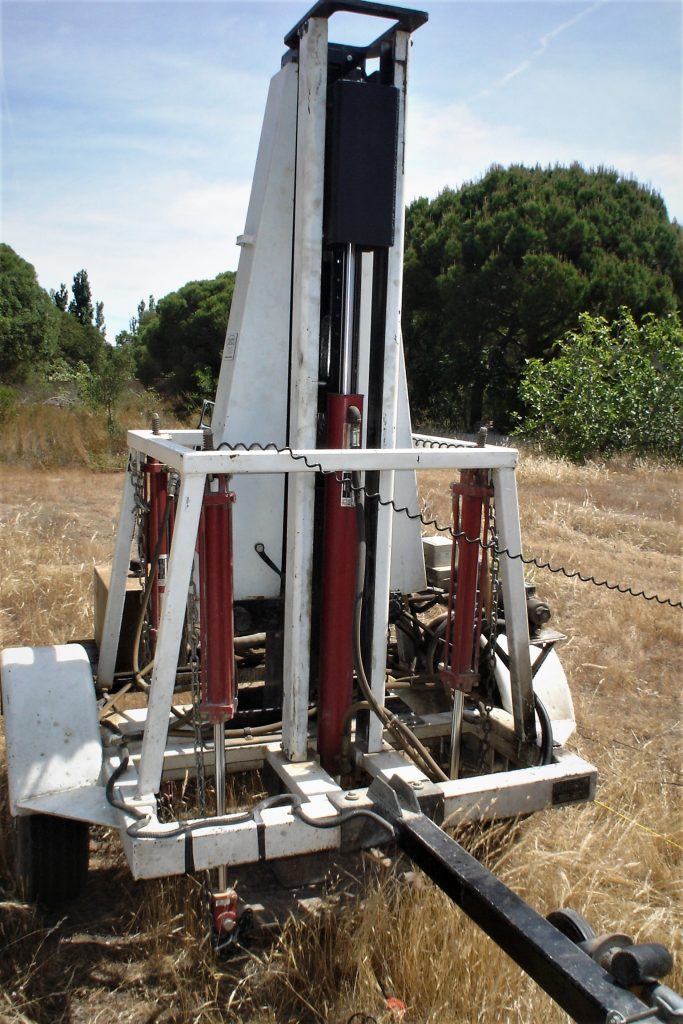
- Downnhole seismic source
- Shear wave sources
- Accelerated weight-drop seismic source 250 kg
- Accelerated mass seismic source with electric elevation
- Dataloggers
- Cables with various takeouts
- Cables/scanners for geophones
- Vertical geophones [4 Hz, 10 Hz, 40 Hz, 50 Hz]
- Horizontal geophones [10 Hz, 40 Hz]
- 3C-geophones [10 Hz]
| + GEOELECTRIC |
- Resistivity meters
- Induced polarization
- Well-logging
- Electrical tomography system
| + GEOELECTROMAGNETIC |
- Georadars
- Antenna for georadars: 100 MHz (monostatic/bistatic), 200 MHz, 270 MHz 400 MHz, 900 MHz, 1600 MHz
- Antenna transport cart with tachometer
- Very low frequency electromagnetics
- Conductivity meter
| + MAGNETIC |
- Portable magnetic susceptibility meter (KT-10 units)
| + RADIOMETRIC |
- Gamma spectrometer
| + WELL-LOGGING |
- Well-logging equipment
Check more EQUIPMENT available via C4G.